
#Early #Map #Savannah #Ga.Takes #Top #Spot #Everard #Sale #Antiques #Arts #Weekly
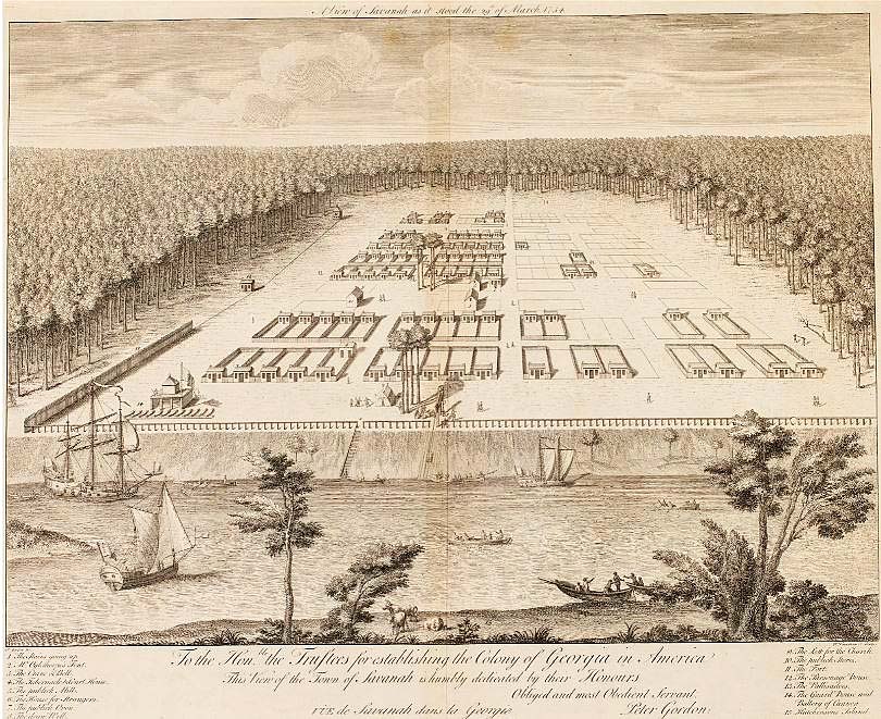
ATLANTA, GA. — Everard’s October 17-18 auction was led by a Peter Gordon (1697-1740) Map of Savannah, 1734, which had a starting bid of $50,000 and rose to $80,000, including buyer’s premium, selling to an online bidder. This rare map represents the first known printed view of Savannah, Ga., and illustrates Georgia colony founder General James E Oglethorpe’s original plan of the city. Only 12 such maps are known to exist in public museums, with a few others in private hands. Titled “A View of Savanah as it Stood the 29th of March, 1734,” the engraving on double-page laid paper with watermark was marked “P. Gordon Inv.” on one side and “P. Fourdrinier Sculp.” Depicted are the original squares with the river and Hutchinson Island in the foreground. The 21½-by-28¼-inch map’s bird’s-eye view differs from other colonial maps in its detailed interpretation of the American wilderness that surrounds the settlement. Watch for additional highlights from this sale in a later review.


